
Engineering Survey for ArtScience Museum
Setting-out survey was carried out to ensure that this unique architecture with uneven and protruding surface, anchored on a round based in the middle is built in the correct position with respect to design. Our experienced surveyors marked out the positions and field parameters on site in order for our Client to construct precisely based on design. The architecture is a reminiscent of a lotus flower designed by the renowned architect Moshe Safdie.
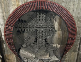
DTSS Tunnel Survey Contract T10
Deep Tunnel Sewerage Systems (DTSS) Phase 2 involves construction of underground network of tunnels and sewers located deep underground on a scale similar to the MRT Tunnels. Our project, DTSS T10 features the deepest shaft across all DTSS contracts measuring 66m deep and involves construction of an 8km tunnel that runs along Clementi Road, Farrer Road and the third one from West Coast Highway to Ayer Rajah Expressway.Our tunnel teams are stationed on site to provide dynamic surveying calculations to guide and drive the TBM (Tunnel Boring Machine) which are 3.5m, 4m and 6m in diameter to travel in the predefined alignment, leading the tunnel to be constructed in the correct position.At Wisescan, we have maintained an impressive track record in providing tunneling survey in bored tunnel as well as cut and cover tunnel. To date, we have completed numerous islandwide tunnelling projects in both Services Tunnel and MRT Tunnels.
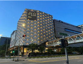
Automated Deformation Monitoring Survey
Round the clock 24/7 Automated Monitoring was carried out in the live MRT tunnels while the 168,100m2 mixed development and regional hub, Paya Lebar Quarter (PLQ) was being constructed.Automated Deformation Monitoring Systems were installed in the live MRT tunnels during the construction period to safeguard existing structures and to determine if the tunnels have experienced displacement. Once the system is set in place, it does not require human intervention. Our fully automated monitoring systems allows for continuous, all-weather monitoring further complemented by intermittent manual checks to ensure results integrity.Measurement cycles are automatically programmed at pre-agreed, customisable cycles. When the monitored movements exceeded a pre-defined trigger threshold, the Client will be alerted via SMS notification.Automated Deformation Monitoring System enables engineers and architects to react to potential issues before they arise. This system can be deployed in the construction of tunnels, buildings, viaduct and any surface areas which require deformation monitoring.

Engineering Survey for Singapore Grand Prix F1
In Engineering Survey, a combination of high precision surveying instrument and digital technology are used to gather data for civil engineering projects. Engineering Surveys are required in different stages in a construction project from gathering and charting existing geographical information, to marking out the position or layout on land including race tracks. Wisescan was appointed as the Surveyor to set out the track positions for the Formula 1 Singapore Grand Prix Circuit.
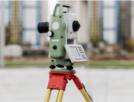
Cadastral Survey to determine boundary
A cadastral survey is a property boundary survey. It is carried out to identify and mark out the property boundary of a parcel of land as described in a deed. It is recommended to carry out a cadastral survey before buying, subdividing or altering a parcel of land for better assurance that your development is being built within your property boundaries.In Singapore, the Land Surveyors Act regulates the conduct of land boundary surveys. A cadastral survey plan has to be submitted by the Registered Surveyor to the Chief Surveyor for approval. The Registered Surveyor will deposit survey documents to the Survey Department at the Singapore Land Authority. On approval of the survey plans, the Chief Surveyor will update the cadastral database and produce the cadastral maps under the Boundaries and Survey Maps Act.
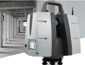
3D Laser Scans and Scan to BIM
In a 3D Laser Scan, high-end LIDAR (Light Detection & Ranging) survey-grade 3D laser scanner is used to conduct 3D laser scanning to capture and collect data and positions for structures, buildings’ exterior (building facades), buildings’ interior or M and E services. The position relative to the scanner is recorded as a X,Y,Z co-ordinate, known as data point. Millions of these data points together make up highly accurate digital images, commonly referred to as point clouds.Scan-to-BIM is the process of using the scanned data or point clouds to create an as-built three-dimensional digital model. The 3D models will include visible items scanned such as wall, column, beam, ceiling, floor, windows, doors, facades, services etc.Our 3D BIM models are geo-referenced to the Singapore SVY21 coordinate system for Easting and Northing (X,Y coordinates) and to the Singapore Height Datum (Z coordinate).

GPS (Global Positioning System) Survey
Global Positioning System (GPS) Survey uses a network of satellites to communicate and to transmit data with the receivers on the ground. By connecting the GPS survey devices to the satellite-based navigation system, the receiver communicates with the satellites to collect data such as the precise location, the time the data was transmitted and the distance between the satellite and the receiver. Coordinates of latitudes and longitudes are then calculated from the collected data.GPS-based survey data collection is much faster than conventional surveying and mapping techniques as it is not bound by line-of-sight visibility between survey stations. The stations can be deployed at greater distances from each other and can operate anywhere with a good view of the sky. Today, GPS is a vital part of surveying and mapping applications around the world.At Wisescan, our team uses sophisticated GPS technology coupled with high quality software to deliver accurate and reliable survey results.

400 hectares Topographical Survey for DSTA
Topographical survey provides an accurate record of the existing visible features and elevation within or abutting the parcel of land to be surveyed.